Thursday, May 10, 2012

Thoroughfare Gap

On March 30th, my structural geology class went on another day trip, this time to Thoroughfare Gap.  It's a gap in Bull Run Mountain by I-66, Rt 55, and the Manassas Gap Railroad.  This area is the beginning of the Blue Ridge and the end of the Piedmont province.  We were to take the orientation of bedding, joints, and veins that were formed by the Appalachian mountain building.  From the data that is gathered, we are to determine the orientation form which the stress came.

View from look out on Bull Run Mountain.

I'm going to start with a brief geologic history of the area.  The supercontinent Rodinia was formed by the Grenville orogeny resulting in the proto-Appalachians. As Rodinia was rifting apart about 700 Ma, the Iapetus ocean was forming.  Sediment from the proto-Atlantic was being eroded due to the rifting and deposited in the new ocean.  This is called passive margin sedementation.  This process created the Chilhowee Group.  The Chilhowee Group consists of the Harpers, Weverton, and the Atietam formations.  The Weverton is the lowest of the group and is overlain the the Harpers and then the Antietam.  The Harpers and Weverton are seen at Throughfare Gap.

The supercontinent Pangea formed as Africa collided with North America in what is known as the Alleghenian Orogeny.  This happened approximately 325 Ma.  As a result, the Iapetus Ocean closed.  This was the beginning of the mountain chain that is the Appalachians.  But all supercontinents must come to an end.  The break up of Pangea lead to the formation the the Atlantic Ocean.  This happened through spreading of normal fault basins.  Not all areas of spreading may form a full rifting sequence. The Culpepper Basin is an example of this.  It did not keep spreading and it filled with dirt.  Had it been the rifting of the Atlantic that failed, the area of the Culpepper Basin would be a vast ocean.


When we arrived to Thoroughfare Gap, we took a hike up Bull Run Mountain.  The majority of the rocks that we had seen were primarily Weverton sandstone.  The sandstone is a quartz arenite which is a clean beach sandstone.  The beds were all dipping to the east.  We also saw some kinked phyllite.

Kinked phyllite.

When we got to the overlook, we stopped for lunch and admired to the view.  You could see straight across to the Blue Ridge were we were to take our next field trip for the class.

View as we ate lunch.

After lunch, we took some orientations of the beds and quartz veins around the overlook.  I had one measurement for the beds- 010°, 75°- and two measurements of quartz veins- 020°, 80° and 005°, 87°.  After about half an hour at the outlook, we headed back down the trail.  The next stop was to an outcrop that was full of joints.  We followed the Manassas Gap Railroad tracks down to the outcrop.

Following the railroad tracks.

When we arrived at the outcrop, we set off to measure the orientations of the  joints, veins, and bedding.

Class measuring orientations at the outcrop.

Milky quartz vein.
From the data gathered, we were to determine how many joint sets there were.  The class shared their data and I put all the data in a stereonet.

Joints potted on stereonet.
Even though this does look very crowded, I prefer it that way so that I can see a trend among the data.  I see three sets of joints in this stereonet.

Trends of joints.

I also plotted the bedding and veins on a stereonet.

Bedding plotted on stereonet.

Veins plotted on stereonet.

I noticed that the orientation of the bedding and the veins are very similar.  I thought that the veins would have an orientation more like the joints because they are essentially "healed" joints.

Field Area 4: Veach Gap

Veach Gap
After field stop 3B, we left Shenandoah National Park and headed towards the Veach Gap Trial.  At this point the weather, which had been so nice throughout the day, turned on us.  The one bright side was that it gave me a chance to try out my new rain gear which I had bough for field camp.  The area that we were in the Massanuten synclinorium.  We were sent out to determine how many anticlines we could find and record the data.  All together there were six anticlines but I only gathered data on three.

One classification used to describe folds is the Hudleston classification.

Hudleston classification.


Anticline 1
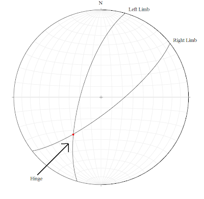
The first anticline has a Hudleston classification of  3C and a Fleuty classification of Upright, Gently Plunging.   There were slickenlines seen on the sides.  The right limb's orientation was 075°, 57° and the left limb was 238°, 55°.

Anticline 1

When plotted on an anticline to find the hinge it looked like this.

Anticline 1 on a stereonet.

Anticline 2
The second anticline has a Hudleston classification of 2D and a Fleuty classification of Upright, Moderately Plunging.  The right limb has an orientation of 090°, 53° and the left is 219°, 50°.  The hinge line is plunging at 35° degrees.

Anticline 2

When plotted on an anticline to find the hinge it looked like this.

Anticline 2 on a stereonet.


Anticline 3
The third anticline has a Hudleston classification of 2F and a Fleuty classification of Steeply Plunging, Upright.  The right limb has an orientation of 052°, 76° and the lift limb is 052°, 76°.


Third anticline.

When plotted on an anticline to find the hinge it looked like this.


Stereonet of anticline 3.

Field Area 3: Limberlost Trial vs. Compton Peak

Day two started out bright and early.  After packing up we drove up to Skyline Drive in Shenandoah National Park.

Sandy Bottom Overlook
Before our class went to the third field area, we made stops to two overlooks.  The first overlook was the Sandy Bottom overlook.

View from Sandy Bottom Overlook.  Photo courtesy of Laura Snyder.


Here we saw some fantastic examples of tension gashes.  The gashes are quartzite and has left-lateral shear.

Tension gashes.  Photo courtesy of Laura Snyder.

Another thing that was seen was skolithos tubes viewed from the top.

Skolithos tubes. Photo courtesy of Laura Snyder.

Franklin Hills Overlook
The second overlook was the Franklin Hills overlook.  This had had rocks from the Catoctin formation.   This formation was from a series of lava flows from the breakup of Rodinia from feeder dikes.  Most of the Catoctin is a meta-basalt called greenstone.  There is also rhyolite, meta-tuff, and metamorphosed sedimentary rocks such as- phyllite and metaconglomerate.  It also has meta-volcanic breccia from lahars and epidote.  In amygdules you may see milky quartz, jasper, chlorite, and zeolite minerals.

Catoctin Formation.


Limberlost Trail

Columnar jointing at Limberlost Trial

At field area 3A, we went on a small hike on Limberlost Trail to get to some columnar jointing.  The material of the joints is meta-basalt.  It formed from the breakup of of Rodinia in the Ediacarin. Basalt columns are a primary structure.  Theese are a product of the Catoctin Formation.  They were exposed to metamorphism during the Alleghanian Orogeny and deformed.  The columns here were tilted.


Class observing the outcrop.


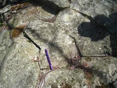
I took measurements of several things.  One was of the angles on the face of a column- 150°, 110°, 145°, 133°, 110°, 116°, 135°.  For the picture below I measured the trend and plunge of the linear triple junction- 088°,65°.


Triple Junction.

This picture’s orientation was 090°, 59°.  The angle between two columns was 65°. 

Triple Junction.


I also took the strike and dip of some joint faces- 050°, 68° and 350°, 62°.  The outcrop also showed arrest lines.  Arrest lines are formed from the cooling of the columns.

Arrest Lines.


Little Devil's Stairs Overlook
After we came back from the hike, we stopped at another overlook- this one called Little Devil's Stairs overlook.  We saw some great examples of feeder dikes.  This showed the basement complex being cute through by the Catoctin.  Unakite was also present in some areas.

Catoctin feeder dike cutting through basement.


Compton Peak
After the stop at the overlook, we were on our way to Compton Peak.  In order to get to this outcrop we had to go on, what I thought to be, a strenuous hike.  Because I was so far behind, I arrived at the outcrop after a majority of the people.  Unfortunately, this meant that I had less time than the others to gather data and measurement and I missed out on the lecture.  When I did arrive though, I was speechless as to what I saw.  I thought the columns at Limberlost Trial were amazing but they couldn’t compare to those at Compton Peak.  

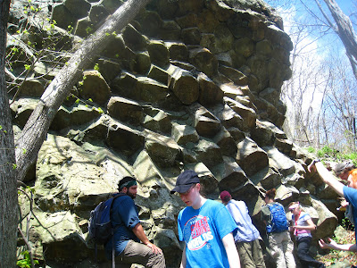
Basalt columns at Compton Trail.

They were much larger, which meant that they had a slower rate of cooling.  I took the orientation of some joint faces- 274°, 47°- 294°, 35°- 337°, 72°.  The picture of the face is below. 

Joint face.

Here's the view looking up.  The best part of the trip, hands down.  I'll gladly go on the hike to see this formation again.

Basalt columns.


Field Area 2: Swift Run Formation


Swift Run Formation
Our second field area required us to go on a hike off the beaten path.  I tredged through the woods, trying not to brush against any poison ivy.  This stop was to the Swift Run outcrop.  There are many different types of rocks here- sandstone, conglomerates and feldspathic wacke.  The feldspathic wacke was close to the source of from the Grenville orogeny.  It came from the deposition associated with the rift valley that became the Iapetus ocean.  We were to look for several primary and secondary structures.  Here’s what I found.


Primary Structures:

Here’s an example of some graded bedding going from coarse to fine.

Graded beds of the Swift Run Formation.


There was also cross bedding in the formation.


Cross bedding


The picture below shows rip up mud clasts.  These were areas of mud that got "ripped up" and deposited with the sands.


Rip Up Mud Clasts.  Photo courtesy of Laura Snyder.


I measured the orientation of the bedding and found it to be
-022°, 74°
-008°, 74°
-010°, 75°
-030°, 55°


Secondary Structures:
There were also areas of folding.
Fold found in swift run


Annotated fold

The picture below is of cleaving over printing the fold.  I took the orientation of the of the cleavage- 075°, 80°.


Cleavage


Extra Stop
Chillhowee Group
Since there was plenty of time left after our stop at Swift Run, we made an extra stop.  This one was to the Chilhowee group which is part of the Harpers formation.  The rocks here are meta-sedimentary.  Some structures seen here were plumose structures.


Plumos structure. Photo courtesy of Laura Snyder.
There was liesegang banding when iron from water stains the rock.


Liesagang banding
The bedding was orientated at 205°, 56° and the foliation was orientated at 025°, 29°.

Stereonet of bedding and foliation.


Field Area 1: Garth Run

Garth Run
Class by the Garth Run outcrop.  Photo courtesy of Laura Snyder.


Garth Run is a mesoproterozoic  aged basement complex.  It's a high shear zone that experiences ductile shear.  It's comprised of many different rock types such as granite, meta granite, granite gneiss, and blue quartz.  Blue quartz is indicative of basement rock in this area.

Blue quartz seen in rocks.

There were many different structures that could be seen in the area.  There was asymmetric porphyroclasts that ranged in size from 2-3 millimeters. It looked like they were comprised of feldspar.  It also looked like they had been stretched out.  This could have been the process of turned into mylonite.  The picture below is what our professor, Callan Bentley, drew to describe the different stages of mylonite.

Stages of mylonite as illustrated by Callan Bentley.

There were many good examples of mylonite at the outcrop.  There was a particularly good example across from the outcrop by the river.  Unfortunately, there was poison ivy everywhere so only those brave enough were able to see it well.  The photo below shows an example of ultra-mylonite.  You can see the folialtion on the rock below.

Ultra-mylonite. Photo courtesy of Laura Snyder.


When measuring the foliations, I found that there were two different sets of foliations-284°, 74° and 030°, 70°.  An explanation for this is that it could be an anticline.  Stress would be coming from both directions- σ1.

Stereonet of the two joint sets.

Garth Run experienced two orogenies, the Grenville and the Alleghenian.  The two joint sets would have been formed during the two different orogenic events.

Weekend Trip to the Blue Ridge and Valley & Ridge Provinces

Overlook from Little Devil's Stairs Outlook.  Photo courtesy of  Laura Snyder.

On April 20th and 21st, my structural geology class took a weekend trip to the Blue Ridge and Valley & Ridge provinces.  We met at 9am at Lot C with all of our field equipment in tow.  After somehow managing to fit all of our stuff in three vans, we departed towards Stanardsville.  Our first stop was to the Heavenly Acres campground to set up our tents.  We then drove to our first field area, the Garth Run high-strain zone.  I'll go into detail about each field area in separate posts. Afterwards we met up with Rick Diecchio, the sedimentary petrology professor at GMU, to go to our second field area, the Swift Run Formation outcrop.  We made an extra stop after to see a Harper's formation outcrop because there was still plenty of sunshine left.  We then headed to dinner and back to the campgrounds to retire for the night.  The next morning after packing up, we drove up Route 33 to Skyline Drive into Shenandoah National Park.  Driving north on Skyline Drive got us to field area 3A, Limberlost trail, where we saw some columnar jointing.  We drove to field area 3B, Compton Peak.  After a strenuous hike off the beaten path, we saw some more magnificent examples of columnar jointing.  We left the park to make our way to our last field area of the day, Veach Gap.  It was at this point that the rain started to come down pretty steadily.  The class took a vote and decided to head back to Northern VA instead of camping another night in the rough weather.


Thursday, March 8, 2012

Billy Goat Trail- Mather Gorge


These are the lamprophyre dikes on the Virginia side of the Potomac River.  There are dikes located on both sides of Mather Gorge.  But while Mather Gorge is straight, the dikes on the Virginia side and the Maryland side are not aligned.  It is unknown why they do not line up.

From  http://www.nvcc.edu/home/cbentley/gol_135/billy_goat/readings.htm   
There are two hypotheses that were discussed in class.  The first and most popular hypothesis is that the dikes were originally straight but they were cut by a fault.  The reason this hypothesis is so popular is because of how straight Mather Gorge is.  It is thought that the river followed the fault, which would be the weakest and easiest path for it to take.  The picture to the left shows "A" as the first theory and "B" as the second theory. The second hypothesis is that the dikes were never straight and were originally jagged.

The structure students took the strike and dip of foliation, bedding, joints, fold limb, and lamprophyre dikes and the trend and plunge of fold hinges.  If Mather Gorge is indeed caused by faulting, the strike and dip of the joints would give us some clues.  When the class data of the joints was plotted on a stereonet, this is what it looked like.


There appear to be about three trends that the joints follow.  However there is still not enough data to conclude anything.  Then I plotted the stereonet of all the foliation, bedding, joints, fold limbs, lamprophyre dikes, and fold hinges.  The result is this.

The purple represents the foliation, the red is the bedding, blue is joints, pink is fold hinge, orange is fold limbs, and the green is the lamprophyre dikes.  However, looking at this the only trend is the green of the dikes.  I believe that the data is scattered because it was a majority of the classes first time measuring strike and dip, therefore there much of the data received is not correct.  And by looking at the data collected it is obvious to see that it is not conclusive enough to state that Mather Gorge is formed from a fault.